The Arctic connection with small island states: the impact of climate change

On a tropical Caribbean island such as Barbados, where I spent this past winter, the impacts of climate change are visible, more than in the Arctic.

Waves pounded this seaside restaurant in 2011, nearly dragging it down to the beach. (PHOTO BY JANE GEORGE)

Waves pounded this seaside restaurant in 2011, nearly dragging it down to the beach. (PHOTO BY JANE GEORGE)

Waves still pound at this restaurant on the west coast of Barbados. Its stairs now dangle over the badly-eroded beach, while in a nearby town, a seaside sidewalk buckles under the pressure of increasingly high tides.

Granted, in the Arctic sometimes it’s hard to see climate change impacts unless you happen to spot a robin or find a new, unfamiliar parasite in the meat of an animal.

Even the contaminants which can poison wildlife and people are invisible and the activities that caused them are located too far away to feel real.

But in Barbados, the sea is there, ready to move in.

Meanwhile, people make efforts to counter this stress on infrastructure by building seawalls, giant mounds of rocks, boardwalks and groynes.

To the left, the first three trees which were chopped off — the others to the right are now only bare trunks. (SUBMITTED PHOTO)

To the left, the first three trees which were chopped off — the others to the right are now only bare trunks. (SUBMITTED PHOTO)

But these efforts can often be counterproductive. On Fitts Beach, also on the western coast of Barbados, a wealthy property owner somehow received permission to cut off the tops of  13 towering Casuarina trees along the beach in front of her property, then the roots were cut back to put in a sea wall.

Now the trunks are beginning to topple over and when they fall, they’ll remove  natural protection against beach erosion.

After being having all the branches chopped off, the trees' roots then were cut off for a seawall. Now the trees are dead and the beach is eroding around what once was a natural wall against the sea.

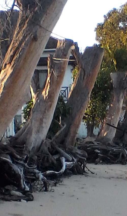
After being having all the branches chopped off, the roots of these trees (seen above with their branches) then were cut off for a seawall. Now the trees are dead and the beach is eroding around what once was a natural wall against the sea. (PHOTO BY JANE GEORGE)

Seeing the forlorn trunks makes many locals angry and worried about the future of their stretch of beach, where huge waves already crash onto the shore, and often spill into yards, covering the grass with sand.

And here’s a sad prediction to think about: Sea level could rise in Barbados as much as two metres by 2080, pushing erosion 100 metres or more inland, way beyond those trunks.

While in Barbados I decided to take an online course with the University of Geneva called “Pathways to climate change adaptation: the case of Small Island Developing States” — which have already joined with the Arctic regions in an organization called Many Strong Voices to combat climate change.

Its common goal: to keep temperature increases in check, so the North stays frozen and the islands stay above sea level.

Like the Arctic, small island nations like Barbados account for a tiny percentage of world energy consumption and produce low levels of climate-warming greenhouse gas emissions. And there are other similarities such as remoteness, a high cost of living and vulnerable economies.

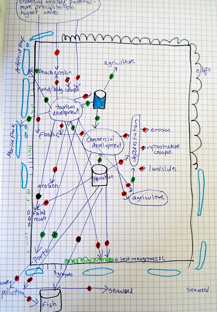
My course on  SIDS tries to get us to think of climate change in a more holistic manner, that everything is connected, that sometimes positives like economic development or protective infrastructure also become negatives and that the solutions to climate change adaptation often lie right at our door — like trees.

For the course, we are asked to draw a diagram showing all the interconnections between the ecosystem, threats and benefits on our island (my example — Barbados.) For that assignment, other students later evaluate my work, and they point out I have forgotten about ocean acidification, coral bleaching and not emphasized overfishing.

There was so much to think about.

af88dd10be9e11e48235cde509d765f4But I did take away the idea that sometimes you to find solutions to climate change  you have to think outside the box or hole we’re all in.

On Barbados, as well as back home, this means looking more closely at development to change before climate change finally changes everything.

As Dr. Keith Nurse, director of the Shridath Ramphal Centre for international trade law at the University of the West Indies in Barbados, told me a few years ago, “we’re digging the hole deeper instead of saying we need a new hole. We’re digging the same hole deeper, and then we’re surprised when it floods.”

Waves pour over into a seaside home on the west coast of Barbados in February 2015. (PHOTO BY JANE GEORGE)

Waves pour over into a seaside home on the west coast of Barbados in February 2015. (PHOTO BY JANE GEORGE)

A makeover for CamBay’s ocean observatory

Hauling a large, 250-pound device connecting hundreds of feet of fluorescent ethernet wire out of icy water is no simple task.

Two University of Victoria divers prepare to raise the ocean observatory. (PHOTO BY JANE GEORGE)

Two University of Victoria divers prepare to raise the ocean observatory. (PHOTO BY JANE GEORGE)

But that’s exactly what a team of divers and young researchers with the University of Victoria and the Ocean Networks Canada project did Sept. 16.

The waters near the Cambridge Bay dock stood at 1.9 C — and would, in fact, start freezing up the next day — but protected by drysuits, two divers managed to bring the marine observatory up to the surface and then hoist it on to the dock for its annual overhaul, a new platform and other new instruments.

By then, the sun was setting in over the Cam-Main North Warning System site to the west — and there would be no time for them to carry on with the plan to take apart the observatory for storage overnight.

Researchers and community volunteers help pull the ocean observatory out of the water. (PHOTO COURTESY OF OCEANS NETWORKS CANADA)

Researchers and community volunteers help pull the ocean observatory out of the water. (PHOTO COURTESY OF OCEANS NETWORKS CANADA)

But they didn’t have a place to store the four-foot-wide triangular device or even a way to move it.

The ocean observatory perches on top of an Adlair Aviation pick-up truck. (PHOTO BY JANE GEORGE)

The ocean observatory perches on top of an Adlair Aviation pick-up truck. (PHOTO BY JANE GEORGE)

Thanks to help from an Adlair Aviation pilot, they managed to lift the platform into the air charter’s pickup truck and bring it up to the airport hangar for safe storage.

When underwater, the device measures such things such as underwater temperature, sounds, salinity and ice thickness. It’s also equipped with a camera — which needs replacement — to keep an eye on the seabed.

Similar observatories have been installed off the coasts of British Columbia, part of Ocean Networks Canada, a University of Victoria project, which “operates world-leading cabled ocean observatories for the advancement of science and the benefit of Canada,” according to its website.

Researchers from the University of Victoria dismantle the ocean observatory for transport Sept. 16. (PHOTO BY JANE GEORGE)

Researchers from the University of Victoria dismantle the ocean observatory for transport Sept. 16. (PHOTO BY JANE GEORGE)

Cambridge Bay’s observatory could be the first in a series to monitor changes in the Arctic.

Launched in September 2012 — and observed by Premier Stephen Harper last month when he visited Cambridge Bay, the observatory will help establish a baseline of environmental conditions, such as rates of ice growth and the timing of algae blooms.

This year, the team plans to service and reinstall:

  • an underwater high definition video camera;
  • an acoustic ice profiler; and,
  • a fish tag receiver from the Ocean Tracking Network.

They also plan to install new instrumentation, including a photosynthetically active radiation sensor that will measure underwater light levels and help scientists study changes during key periods, such as spring, when the polar sunrise triggers algae blooms under the ice.

A sea snail retrieved from  the seabed near the ocean observatory. (PHOTO BU JANE GEORGE)

A sea snail retrieved from the seabed near the ocean observatory. (PHOTO BY JANE GEORGE)

Above water, a video camera will continue to monitor surface ice formation and the weather station will provide real-time atmospheric conditions.

An antenna positioned on top of a nearby building will continue capturing signals from nearby ships, a project website says.

Divers plan to sample fauna on the sea floor, and look for a new observatory location in 2015.

This will position the underwater sensors at a greater distance from vessels and winter road traffic near the busy Cambridge Bay dock.

Among the interesting tidbits learned to date by the observatory about air and sea water temperatures during the winter in Cambridge Bay:  while winter air temperatures frequently dip below -30 C, water beneath the ice remains near 0 C.

Then, during the summer, prolonged sunshine raises air temperatures and melts the ice, raising seawater temperatures to about 10 C.

And, in November 2013, the observatory caught the sound of ice cracking as a snowmobile travelled over the ice near the Cambridge Bay hydrophone. The snowmobile broke through the ice a short time later.

The University of Victoria team plan to wrap up their work some time next week after they meet with local students and people in the community to talk about their project.

Look for more posts from Cambridge Bay, Nunavut.

Recent posts on A date with Siku girl include:

Canada ignores Arctic infrastructure: veteran ice pilot

New roof, new life for CamBay’s old stone church

Two Arctic ships, two explorers: Franklin and Amundsen

Today, Arctic explorers take cruise ships